When a new field is opened, the TLuser.txt file is read, and predefined layers using #LAYER directive are loaded.
Layers are a powerfule data management tool. They allow data to be maintained in a single file, but separated by type.
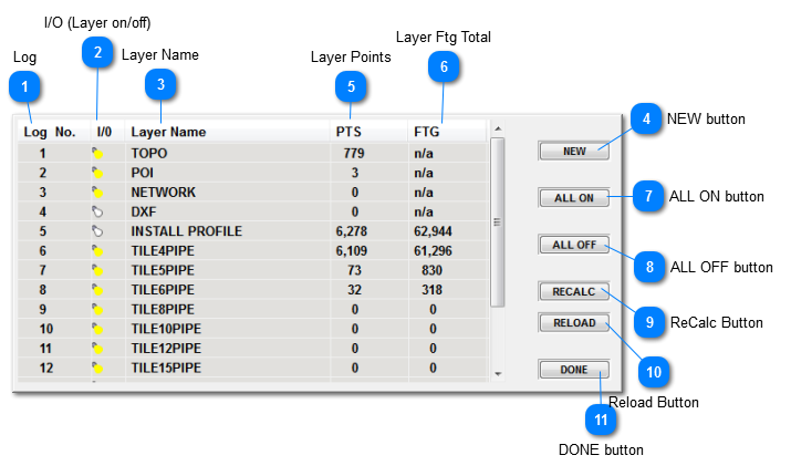
System Layers
Layers 1 through 5 are considered system layers. These cannot be deleted or their properties changed. They may be turned on/off, but nothing else.
1. TOPO - Default location for topographical data. Alternately, other layers may be defined with style TOPO, which is alterable. Note, width and color have no meaning for layers with this style.
2. POI - All POI's (Points of Interest) are created on this layer.
3. NETWORK - the layer which hold Landrain Network file (.NET) overlays. if one is loaded. Note, "NETWORK" will be replaced with the overlayed file name.
4. DXF - the layer which holds DXF overlays, if one is loaded. Note, "DXF" will be replaced with the overlayed file name.
5. INSTALL PROFILE - Default location for install profile data, created by machine performing a survey pass.
Layers ON or OFF?
Aside from that fact layers which are off are not displayed, the concept of turning layers on/off is important in TileLogic Office. Often operations will only work with data that is on layers which are on.
Examples of this are:
Contour lines - Contours will only be generated, based on data layers specified as TOPO style. which are currently ON.
Export to Landrain - Only data layers which are ON, will be output for Landrain import. Be careful, export to LD L, X, Y, ZN option, should ONLY INCLUDE DATA WHICH IS CONSIDERED RELEVANT TO THE TOPOGRAPHICAL MODEL GENERATION.
Log
The current layer that is selected for logging (mapping). This is not applicable in TileLogic Office.