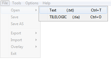
Text files can be opened directly using TileLogic Office. Text files are generic, human readable data, usually separated by commas or some "delimiter" which defines data fields. The first line of a text files data, is assumed as the benchmark.
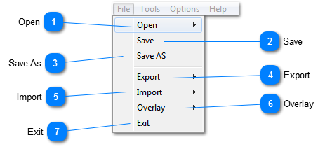
Export the current file to another file format for use with another application.
Important: ONLY LAYERS WHICH ARE CURRENTLY ON WILL BE EXPORTED. This allows you to define the range of data you wish to export. Example, if you only wish to export topographical data, only turn on layers with the style TOPO, and export.
CSV - output data in text format, using Comma Separated Values format. Note: the first line of this file will contain data field headers.
DXF - Opens the DXF creation window, and allows for exporting to generic CAD format.
LD L,X, Y, ZN - Exports data easily to text format readable in Landrain, using the format L (Label), X (Easting), Y (Northing), Z (elevation), N (end of line). When importing into Landrain, specify L,X, Y, ZN (commas are important).
LD NET - Export layers which have EX_TILE or LINE styles as a network file, directly readable by Landrain. Useful when existing tiles have been mapped, and need designed around. Additionally, poi's may be exported as fixed nodes. This could be useful, say for marking boundary posts, or an outlet location.
ESRI SHP - opens a window, to select export options for shapefiles, used with many GIS applications.
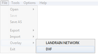
Currently, Landrain Network files and/or DXF formatted files may be overlade onto the current file. Note that the data is not imported or merged with the current data, but simply the image is overlade onto the screen.
Overlaying Landrain .NET files is useful for previewing, and can be exported to ESRI shapefiles when overlaid.