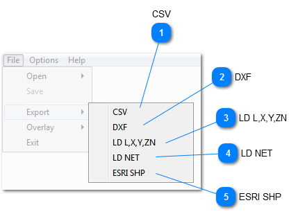
Outputs data formatted for coordinate input with LandrainTM surface files. Note that "L, X, Y, ZN" as shown in the menu item has significance. This is the format of the data format, and should be the same specified in Landrain as well.
The meaning of this is:
L, = Label, simply the data item number, i.e. 1, 2, 3, 4 etc., delimited by a COMMA (The comma must be spelled out in Landrain).
X, = X coordinate, followed by a COMMA
Y, = Y coordinate, followed by a COMMA
Z = Z coordinate, NO COMMA
N = Read NEXT line (or end of data this line).
Example in Landrain. Use Coordinate Input and specifiy:
L, X, Y, ZN - Right
LXYZN - Wrong
Only data on layers which are currently ON will be output!
BE CAREFUL, ONLY INCLUDE DATA WHICH IS CONSIDERED RELEVANT TO THE TOPOGRAPHICAL MODEL GENERATION.
Outputs line type data to LandrainTM network format, for direct use.
Only data on layers which are currently ON, and have the styles "POI", "Line" or "EX_Tile" will be output! Note, that POI's are created as "fixed nodes".
This is very useful to incorporate probed lines, pipelines, or anything that must be incorporated into a design. Also, POI's can be used, for example to indicate property markers.