TileLogicTM             
 
Menu

Toolbar

Toolbar
1

Open Icon

1. Open Icon
 
Quickly opens standard TileLogic files.
 
2

Print Icon

2. Print Icon
 
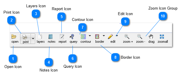
Left mouse button click on printer icon opens the print preview window.
 
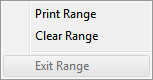
Left mouse button click on down arrow opens the print range menu.
 
 
Select Print Range to define a rectangular print area of the current map to print.  Left mouse click on map window, and drag rectangle to define the print area.  When complete select EXIT RANGE or press ESC key to exit range mode.
 
 
Select Clear Range, to clear any defined range, and print the entire map extents.
 
3

Layers Icon

3. Layers Icon
 
Opens a layer window, for layer manipulation.
 
4

Notes Icon

4. Notes Icon
 
Opens the notes window.
 
5

Report Icon

5. Report Icon
 
Opens a window for previewing and printing a field report preview.
6

Query Icon

6. Query Icon
 
Click to enter Query mode. 
 
Click a map location OR a data point in the data list to see the nearest point highlighted, both on the map, and in the data display to the left.  Useful for reading POI comments.
7

Contour Icon

7. Contour Icon
 
  • Toggle View - Toggles contour display on/off
  • Set up - Opens a Contour window to generate or define contour paramaters.
 
8

Border Icon

8. Border Icon
 
  • Toggle View - Turn border display on/off, as well as clipping when clipping borders have been used.
  • Undo - if a previous operation was performed, allows undo.
  • New Open Border - Create a polyline property border.  Useful for internal property lines with a multiple tract survey.
  • Remove Borders - options for removing borders which were previously created.
  • Border Edit - Enter Border Edit Mode
  • Exit Borders - Exits from Border Edit Mode.
     
 
9

Edit Icon

9. Edit Icon
Drops down an editing menu.  If data is available within a group, the listed item is not grayed, and may be selected. 
 
Note: Currently, POI / TOPO/ Mapped Points are grayed by default and are not available for graphic editing.  Reserved for future use.
 
  • Undo  - if an operation has been performed, undo is available.
  • POI    - Reserved
  • TOPO - Reserved
  • Mapped Lines  - If data with style EX_TILE or LINE are present, select to enter Line Edit mode.
  • Mapped Points - Reserved
  • Exit Edit - Select to exit editing mode or press ESC key.
     
10

Zoom Icon Group

10. Zoom Icon Group
 
  • Zoom +   Zoom in.
  • Zoom -    Zoom out
  • drag        Drag screen by left click mouse - hold down - move to new position - release.
  • zoomall   Zooms to map extents