TileLogicTM             
 
Menu

Export

Export
 
 
1

CSV

1. CSV
 
Export data to a CSV (comma separated files) format.
 
 
Only data on layers which are currently ON will be output!
 
Example, first three lines of an output file...
 
TYPE,LATITUDE,LONGITUDE,ALT,X,Y,Z,COMMENT
0, 40.04046,-88.775168, 722.44094598, 1000, 1000, 91.07,"end of day 2"
1, 39.98173983763,-88.51977902007, 715.72607421875, 1.69904988605091, 100.588762010338, 98.4488525390625,""
 
Note that the first line contains field headings. 
 
This format is useful for importing to spreadsheets.
 
2

DXF

2. DXF
 
Export data to a DXF format.
 
All data layers, except 3 and 4 will be written.  Even if the layers are off. 
 
DXF files are widely used with CAD programs as a generic format.
 
3

LD L,X,Y,ZN

3. LD L,X,Y,ZN
 
Outputs data formatted for coordinate input with LandrainTM surface files.
 
Only data on layers which are currently ON will be output!
 
 
4

LD NET

4. LD NET
 
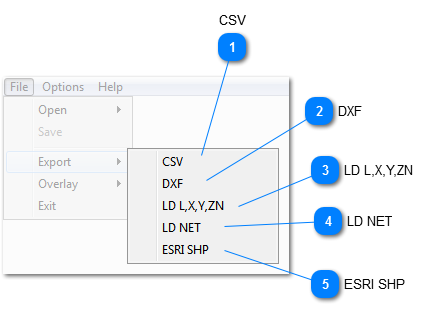
Outputs line type data to LandrainTM network format, for direct use.
 
Only data on layers which are currently ON, and have the styles "POI", "Line" or "EX_Tile"  will be output!  Note, that POI's are created as "fixed nodes".
 
 
This is very useful to incorporate probed lines, pipelines, or anything that must be incorporated into a design.  Also, POI's can be used, for example to indicate property markers.
 
5

ESRI SHP

5. ESRI SHP
 
Export to Shapefile format used with many GIS programs.  Opens a save file window followed by Shapefile data and shapes selection window.