TileLogicTM             
 
Menu

Import Text File Data window

Import Text File Data window
 
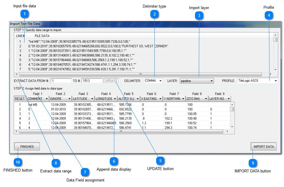
This window is a powerful text file data importer that is highly configurable.
 
Caution:  It is strongly advised that a new layer is created PRIOR to using this feature, and that this new layer is designated as the "import layer".   Doing so will allow for trial and error, until you are familiar with this powerful data importer.  Appending this data to a new layer, will allow it to be deleted and redone, until satisfied with the results without jeopardizing existing mapping data.
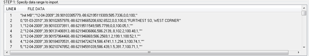
 
 
1

Input file data

1. Input file data
Displays the actual data as seen in the input file.
 
2

Delimiter type

2. Delimiter type
Choose a data field delimiter.  A delimiter differentiates the fields, so that data items are separated.  Often this is a comma, but choices include:
 
  • COMMA
  • SEMICLOLON
  • TAB
  • SPACE
  • |
 
3

Import layer

3. Import layer
Select the layer from this dropdown box to import and append this data to.
 
4

Profile

 
4. Profile
Up to 10 profiles may be saved for different data file formats.   To save, select a profile, and type in the name you wish to use.  Note that by default, profiles are named "USER DEF X, where X = 1 thru 10.
 
This profile will be saved on exit.
 
5

UPDATE button

5. UPDATE button
When the extracted data records are changed by the user, click this button to refresh the append data display.
 
6

Append data display

6. Append data display
Displays the lines which will be appended.
 
7

Data Field assignment

7.  Data Field assignment
There are available, up to 9 data fields for data import.
 
For each field, as separated by the delimiter, you must designate what TYPE of data field it is, so that it may be properly interpreted upon import.
 
For each field choose from the following in each of the field 1 - 9 drop down boxes:
 
  • IGNORE - ignores the field, not imported.
  • X EASTING - X coord <mandatory>
  • Y NORTHING - Y coord <mandatory>
  • Z (TO BM) - Z coord relative to a benchmark <mandatory>
  • LATITUDE - <optional>
  • LONGITUDE - <optional>
  • ALT(TO SL) - this is the elevation as reported by the GPS, generally relative to sea level. <optional>
  • COMMENT - text comment <optional>
  • LAYER NO. - a layer number assignment <optional>
 
Click RESET to restore all fields to IGNORE.
 
8

Extract data range

8. Extract data range
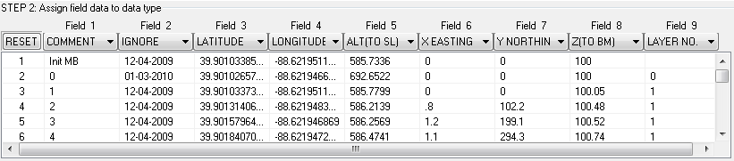
By default, when this window is opened, all data items in the input data are selected for import.  This can be changed however, by editing the values in the above boxes OR by clicking on the records in the input file data (for selecting multiple records, left click on the first record, and SHIFT + left click on the last record you choose).
 
9

IMPORT DATA button

9. IMPORT DATA button
Click to import the data. The data will be appended to the layer selected. This button will be disabled, until all mandatory data fields are defined.
10

FINISHED button

10. FINISHED button
Click to exit without importing data.  This will save defined profiles.