|
The AUTOPOI is available for use when a POI needs to be set, but the GPS must be dismounted to get to the point of interest.
This requires the operator to be away from the computer, the use of a different length rod (from the standard vehicle mounted height), or both.
|
Scenario #1 - Take an elevation reading on a ditch channel.
Issues:
-
The ditch is deep, and requires a tall rod to mount the GPS receiver onto to get a good signal.
-
The GPS receiver is normally mounted on an ATV, and the height above the ground surface is 4.5'.
This is the standard vehicle mounted height as referred to in this document. It was at this height at which the field bench was set. Once this is verified, continue by selecting
SET POI from the Mapping window.
The following window appears:
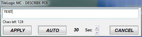
1. Enter a description. For this example, "TEST" was entered.
2. Adjust the "seconds" more or less, as you need.
Select "AUTO", and the following similar count down screen appears:
A beep will be heard each second that counts down.
Once 10 seconds is left, a higher pitched tone sounds to alert you. (Make sure you are in position, and the GPS has been held steady.)
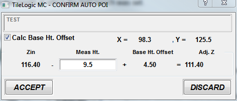
Once the count down times out, the following screen appears:
Remember issue #1, we needed to use a longer rod to get a good signal.
In this case, our rod used to mount the GPS was 9.5' tall.
Therefore, CHECK the box for Calc Base Ht. Offset. (This tells TileLogic that the rod height is not the 4.5 that was standard. Note the 4.5 appears in Base Ht. Offset.)
We now type into the Meas. Ht. box, our new rod height of 9.5'.
What has happened is that the new rod height is backed out, and the standard height is added. This compensates for the non-standard height, and gets us back to an elevation relative to the bench. Another way to think of this, is that we get to an elevation that is the same as if we could take a POI with the vehicle at this location.
Choose ACCEPT to save the POI.
Review:
When removing the GPS from it's standard mount and using a non-standard rod:
Scenario #2 - Take an elevation reading on a Culvert Invert.
Issues:
-
The culvert cannot be reached by the survey vehicle, and the operator must be away from the computer while holding the rod with GPS receiver.
-
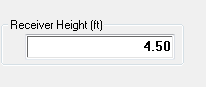
The GPS receiver is normally mounted on an ATV, and the height above the ground surface is 4.5'.
-
Our mobile rod height is the same length as the vehicle standard mount. (4.5 in this case)
This is the standard vehicle mounted height as referred to in this document.
It was at this height at which the field bench was set.
Once this is verified, continue by selecting
SET POI from the Mapping window.
The following window appears:
1. Enter a description. For this example, "TEST" was entered.
2. Adjust the "seconds" more or less, as you need.
Select "AUTO", and the following similar count down screen appears:
A beep will be heard each second that counts down.
Once 10 seconds is left, a higher pitched tone sounds to alert you.
Make sure you are in position, and the GPS has been held steady.
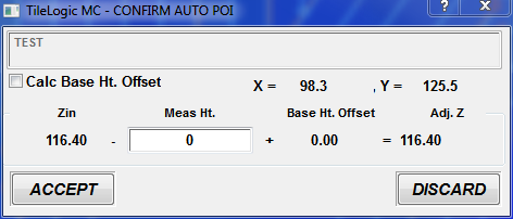
Once the count down times out, the following screen appears:
In this case, our rod used to mount the GPS was 4.5' tall (the same as the vehicle mounted height).
Therefore, DO NOT CHECK the box for Calc Base Ht. Offset.
Insure the value in the Meas. Ht. box is 0.
In this case, since our mobile rod length was the same as the vehicle mounted height (4.5 in this case) we do not need to make any elevation compensations. We simply needed to use the AUTOPOI feature because we had to be away from the computer, while holding the rod.
Choose ACCEPT to save the POI.
Review:
When removing the GPS from it's standard mount, but using a rod the same length as the standard height :