TileLogicTM             
 
Menu

TOOLS window

TOOLS window
 
Display a window of useful map tools.
When displayed, the map background is always displayed as black.
1

Edit icon

1. Edit icon Clicking on this box, and selecting a point on the map will open the edit window.
2

Slope icon

2. Slope icon Clicking this icon allows the user to find the distance and slope % between 2 mapped points.
  1. Left click and hold it down on start point while dragging to the second point.  The nearest points will be used.
  2. A small window be displayed:
 
The point to point id's are shown in the title.  In this case, the distance between lines was 1,282', with a slope of -.202%.
 
This window will be displayed until you either:
  • exit the window (click on X) OR
  • exit the Tools dialog
3

Zoom + icon

3. Zoom + icon 
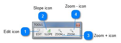
Clicking this icon changes the pointer to   and allows zooming in on any area of the map.  This differs from the standard mapping zoom, which zooms in based on the current coordinates location.
Tip:  Right clicking while in zoom toggles between zoom in (+) and zoom out (-)
4

Zoom - icon

4. Zoom - icon Clicking this icon changes the pointer to   and allows zooming out on any area of the map.  This differs from the standard mapping zoom, which zooms out based on the current coordinates location.
Tip:  Right clicking while in zoom toggles between zoom in (+) and zoom out (-)